The ongoing exhibition, titled 'The Ruins of Kočo: Traces of Wooden Architecture from the Ancient Silk Route', at the Museum of Asian Art, Berlin, will end on January 8, 2017. This is your last opportunity to check out the objects from the Tufran expeditions at the museum.
The temple city of Kočo (Chinese: Gaochang) is located near Turfan, in the Xinjiang Autonomous Region, China. More than 100 years after the return of the Berlin researchers from Central Asia, new discoveries are still being made from that time on. Painted wooden beams inscribed with Buddhist texts that were brought back by Albert Grünwedel are now being considered as pieces of a ceiling and a door. This discovery prompted a team from the museum to visit the temple city of Kočo, where they searched for wood architecture and analyzed reports and photographs from three Turfan expeditions, which gave birth to new understandings of the monastery buildings that are on display at the exhibition. The exhibition will also showcase unique objects found in the three buildings analyzed in Kočo, which will act as a preview of Humboldt Forum. Painting, texts and sculptures in Buddhist and Manichaean monasteries, as well as architectural elements of everyday life, shed new light on that era.
The exhibition is on view at the Museum of Asian Art, Lansstraße 8, 14195 Berlin, Germany.
The eight studies in this volume by established and emerging scholars range geographically and chronologically from the Greek Kingdom of Bactria of the 2nd century BCE to the Uighur Kingdoms of Karabalgasun in Mongolia and Qoco in Xinjiang of the 8th-9th centuries CE. It contains a key study on sericulture as well on the conduct of the trade in silk between China and the Roman Near East using archaeological as well as literary evidence. Other topics covered include Sogdian religious art, the role of Manichaeism as a Silk Road religion par excellence, the enigmatic names for the Roman Empire in Chinese sources and a multi-lingual gazetteer of place- and ethnic names in Pre-Islamic Central Asia which will be an essential reference tool for researchers. The volume also contains an author and title index to all the Silk Road Studies volumes published up to 2014. The broad ranging theme covered by this volume should appeal to a wider public fascinated by the history of the Silk Road and wishing to be informed of the latest state of research. Because of the centrality of the topics covered by this study, the volume could serve as a basic reading text for university courses on the history of the Silk Road.
Table of Contents
1. JOSEF WIESEHÖFER Greeks, Iranians and Chinese on the Silk Road 2. ULRICH HÜBNER Palestine, Syria and the Silk Road 3. WERNER SUNDERMANN Manichaeism on the Silk Road: Its Rise, Flourishing and Decay 4. THOMAS THILO Chang’an – China’s Gateway to the Silk Road 5. GUNNER MIKKELSEN Religious Convergence in Sogdian Funerary Art from Sixth-Century North China 6. SAMUEL N. C. LIEU Da Qin 大秦 and Fulin 拂林 – the Chinese Names for Rome
7. SAMUEL N. C. LIEU & GUNNER MIKKELSEN Places and Peoples in Central Asia and in the Graeco-Roman Near East – A Multilingual Gazetteer from Select Pre-Islamic Sources 8. LYNDON A. ARDEN-WONG Some Thoughts on Manichaean Architecture and its Application in the Eastern Uighur Khaganate
The Buddhist collection of stories entitled Dasakarmapathavadanamala (garland of legends pertaining to the ten courses of action) is the most important narrative work of Buddhist Central Asia as it is not only attested in Old Uyghur (the best preserved version) but also in Tocharian A and B as well as in Sogdian. Volumes one and two present the reconstructed text in Old Uyghur in transcription (more than 12.500 lines) and facing German translation accompanied by a philological commentary and 250 illustrations of joint fragments. The third volume contains a glossary and the transliterations. The text is a treasure trove of Buddhist j?takas (stories of former lives of the Buddha) and avad?nas (heroic deeds) sometimes told in variants unknown from other Buddhist works. In addition, it contains instructions referring to Buddhist ethics. Next to the Maitrisimit, the Dasakarmapathavadanamala is the second fundamental text translated from Tocharian A and is thus of major importance for Tocharian studies.
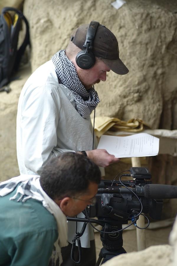
Poring over National Geographic magazines and dreaming of adventure while growing up in small-town Ohio, Medill Prof. Brent Huffman never imagined he would be making repeated trips into Taliban-controlled Afghanistan to chronicle Afghan archaeologists’ race against time — but beginning in the summer of 2011, he did just that.
The documentary filmmaker spent three years traveling in and out of the country to cover the excavation of Mes Aynak, an ancient Buddhist city near the Pakistan border that has been purchased by a Chinese mining company for its wealth of copper.
Huffman filmed the documentary, which followed the archaeologists working to save some of Mes Aynak’s artifacts before mining begins, over the course of a three years, all done in five or six trips of two to three weeks to the archaeological site.
“Looking back, it was a very ‘Indiana Jones’ sort of experience,” Huffman said. “It was really dangerous to go out there, but I felt the risk was worth it.”
The risk did pay off for Huffman. His film, “Saving Mes Aynak, won a $50,000 grant from The Reva and David Logan Foundation earlier this month, and was picked up by international distributor Icarus Films.
Getting it to this point, though, was a challenge, Huffman said. Setting out with a grant from the Buffett Institute and without a crew — he said he didn’t want to put other people at risk — Huffman joined up with a local “fixer,” someone who spoke the language and understood the customs, and began filming in June 2011.
Working without a crew, however, had challenges beyond simply the logistical.
“When you’re a crew of one, you feel that obligation and that pressure to get the story out there,” Huffman said. “If I was killed, the story would die too. There’s no one who’s going to pick up that story and finish it.”
Telling stories, particularly about people or issues he says are often ignored or misrepresented in the media, has always been one of Huffman’s passions. One of his first forays into filmmaking was a documentary he made in college about a maximum security prison in Ohio that focused on the individuals spending their lives behind bars and the corrections officers supervising them.
Growing up in the “one-stoplight, really tiny middle-of-nowhere, surrounded-by-Amish-country” town of Spencer, Ohio, Huffman said he was always more of an outsider, which drew him to stories about other outsiders, particularly marginalized and oppressed cultures in the U.S. and abroad.
He said he was interested in film while he was growing up, and his National Geographic subscription fueled fantasies of traveling and having adventures beyond his hometown.
After high school, he pursued his interests with majors in documentary filmmaking and anthropology at Antioch University in Ohio, which he capped off with a master’s degree in journalism with a documentary focus at the University of California-Berkeley.
“I loved art and was really interested in anthropology — and still am — and documentary filmmaking really combined all of that for me,” he said. “It allowed me to become a part of people’s lives in a way that I couldn’t otherwise and to tell people’s stories.”
He’s also worked to instill the same passion for storytelling in students, those in his documentary filmmaking classes and outside them.
Hannie Lee (Communication ’15) began working with Huffman in January of her senior year, and is currently an outreach assistant working on “Saving Mes Aynak” at Kartemquin Films, a documentary production company that’s been working with Huffman on the film. Lee said working with Huffman has helped her learn to focus on the little aspects of storytelling that make a large impact and to stick with stories.
“He is always like, ‘go out and shoot something,’ rather than think ‘oh, I can’t do it because there’s no story there,’” Lee said. She added that he’s also quite literally enabled her to “go out and shoot something,” lending her his equipment to use for a documentary project as part of her internship.
Huffman’s interest in storytelling, as well as traveling, would eventually lead him to China, where he and his wife, who is Chinese, worked for a National Geographic offshoot after graduate school. Although he came back to the U.S. after several years, teaching at the Brooks Institute in California and later at NU, China remained at the back of his mind, so when he read a The New York Times article about a Chinese mining company setting up in Taliban country, he decided to pursue it further.
The next six years, which also included the birth of his two children, would see this one idea from a The New York Times article grow into an hour-long film with nearly 100,000 Facebook fans and screenings across the globe.
“At great personal cost and risk he went and filmed in an area of the world that not many people go to to film in,” said Tim Horsburgh, director of communications and distribution at Kartemquin Films. “(The film’s online following) is really a testament to Brent recognizing that this is an issue people would be passionate about and sticking with it.”
Huffman himself is very passionate about Mes Aynak. While the film is finished, he said his work is not. Although the film “doesn’t end with bullet points saying this is what should happen,” his ultimate goal in making the film is to permanently prevent mining at Mes Aynak so it can be preserved and explored.
“Making a film, telling this complete story that has an emotional impact — when you cry at a film, it ceases to be just this point of entertainment,” Huffman said. “Emotion can drive energy and be a catalyst for change.”
A very interesting international conference on “Monuments and Pastoral Regimes - Archaeology of Inner Asia from the Eneolithic to the Early Iron Age” will be held in Bonn, March 2-4 2017 Monuments and Pastoral Regimes - Archaeology of Inner Asia from the Eneolithic to the Early Iron Age LVR-LandesMuseum, Colmantstr. 14-16, 53115 Bonn March, 2-4, 2017
Thursday, March 2, 2017 Conference Opening 15.00 Ursula Brosseder (Bonn), Introduction Session 1 Framework – Social dynamics Chair: Ursula Brosseder 15.30 Joshua Wright (Aberdeen), Integrated Narratives: The local and the long term in three regions of Mongolia 16.00 Esther Jacobson-Tepfer (Eugene), The Texture of Life in the Bronze Age: The Case of Two Valleys in the Mongolian Altai 16.30 Nikolai Kradin (Vladivostok), Heterarchy and Hierarchy in slab grave society 17.00-18.00 Break Evening Lecture 18.00 Michael Frachetti (St. Louis), New model civilizations: Institutional Participation and the Formation of Central Asia’s Open Ecumene 19.00 Reception for speakers and chairs in DelikArt Friday, March 3, 2017 Session 2 Metals, Connectivity and Elites Chair: Henri-Paul Francfort 09.00 Nikolaus Boroffka (Berlin), Central Asia - Bronze Age metallurgy and its social significance 09.30 Yiu-Kang Hsu (Oxford), Charting metal supplies in late -prehistory northern China: reflections from the lead isotope analysis 10.00 Zhang Liangren (Nanjing), Prehistoric East Xinjiang, Gansu, and Southern Siberia: technological transmission, trade, and innovation 10.30 Coffee Break Session 3 Animals and People, Lifeways and Diet Chair: Ursula Brosseder 11.00 Gisela Grupe (Munich), Life-ways and diet, first results from the joint BARCOR project 11.30 Alicia Ventresca Miller (Kiel), Shifting diets across Xinjiang, northern China, Mongolia and southern Russia 12.00 Vincent Zvénigorosky, Eric Crubézy (Toulouse), Association between cultural and paleogenetical data in Mongolia and surrounding areas at the time of the Late Bronze and Early Iron Age 12.30–14.00 Lunch Session 3 Animals and People, Lifeways and Diet Chair: Joshua Wright
14.00 Cheryl Makarewicz (Kiel), The human-animal relationship in ancient mobile communities of the Mongolian steppe: Subsistence and ceremony 14.30 Natalia Tsydenova (Ulan-Ude), The Eneolithic, Early Bronze Age and the adoption of pastoralism in Transbaikalia and Mongolia 15.00 Jean-Luc Houle (Bowling Green), Seasonal Gatherings and Animal Sacrifice: The role of ritual and climate in the emergence of societal complexity 15.30 Coffee Break Session 4 Monuments and Landscape - Overview Chair: Jan Bemmann 16.00 Tsagaan Turbat (Ulaanbaatar), New insights into the Bronze and Early Iron Age of Mongolia 16.30 Jamsranjav Bayarsaikhan (Ulaanbaatar), From Deer to Horse: Symbolism on Mongolian Ritual Stone Stelae Saturday, March 4, 2017 Session 5 Monuments and Landscape – a close-up image Chair: Tsagaan Turbat 9.30 Ursula Brosseder, Chimiddorj Yeruul-Erdene (Bonn), Jamiyan-Ombo Gantulga (Ulaanbaatar), Monuments and Memory – BARCOR 10.00 Jamiyan-Ombo Gantulga (Ulaanbaatar), J. Magail (Monaco) Results from the Khoid Tamir-Khünüi Project, Central Mongolia 10.30 Aleksei Tishkin (Barnaul), The Bronze and Early Iron Age in the Altai 11.00 Coffee Break Session 6 Monuments and Landscape – The West Chair: James Williams 11.30 Guo Wu, (Beijing), Khirigsuurs and the Bronze and Early Iron in Dzhungaria 12.00 Ma Jian (Xi’an), A study on figure-shaped tombs and slab graves from Yinshan Mountain 12.30–14.30 Lunch Break Session 7 Monuments and Landscape – The East Chair: Zhang Liangren 14.30 Kazuo Miyamoto (Kyushu), A comparative study on slab graves in Mongolia 15.00 James Williams (Beijing), Upper Xiajiadian in Northeast China: Economic and Ideological Connections to Inner Asia 15.30 Resumé and Final Discussion (Henri-Paul Francfort) 18.00 Dinner for Speakers and Chairs
Information on Accomodation and Conference Venue
University of Bonn Pre- And Early Historical Archaeology Regina-Pacis-Weg 7, 53113 Bonn, Germany +49(0)228-736378; Fax: +49(0)228-737466 Due to limited seating capacity, guests are kindly asked to register in advance by sending an e-mail to ursula.brosseder@uni-bonn.de. Conference fee: 100€, student discount: 50€
Accomodation for speakers and chairs: Hotel Europa: (Thomas-Mann-Str. 7-9) http://www.hotel-europa-bonn.de/en/ Conference Venue: LVR-LandesMuseum, Colmantstr. 14-16, 53115 Bonn http://www.landesmuseum-bonn.lvr.de/en/startseite.html
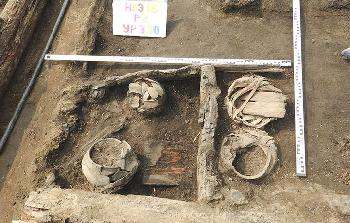
Mummified potentate and wife were found in burial mound 42 metres in diameter, and they went to the next life alongside 9 geldings, saddled and harnessed.
Tattooed owners of the world's oldest carpets get health check after 2,200 years. Picture: Dmitry Koshcheev
New technology has been used to obtain the secrets of two ancient mummy's excavated from their graves in the Altai Mountains in 1949.
The pair are seen as a local chieftain from the Pazyryk culture and his wife or concubine who was incarcerated alongside him, evidently with cannabis burning in the burial chamber.
Their remains - preserved because they were encased in ice for thousands of millennia in the valley of the River Bolshoy Ulagan - are held in the Hermitage Museum in St Petersburg.
This scan is the first of its kind for the world famous Hermitage. Picture: The State Hermitage Museum
Now the body of the curly-haired male, between 55 and 60 when he died, and the woman, some ten years younger, have been scanned to create tomograph images using a Siemens SOMATOM Emotion in 16 separate modes.
Multi-disciplinary analysis will be undertaken including radiologists, biological anthropologists, archaeologists and other scientists, with the results announced later.
This scan is the first of its kind for the world famous Hermitage. The aim is to establish the cause of death, and reconstruct the appearance of the ancient pair, and to study the techniques of mummification in more detail.
Their remains were preserved because they were encased in ice for thousands of millennia in the valley of the River Bolshoy Ulagan, Altai Mountains. Pictures: The Siberian Times, StanRadar, Sergey Rudenko
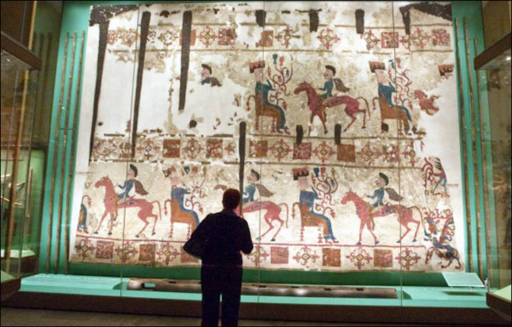
Most of the treasures of the grave were robbed in prehistoric times, but famously two carpets remained - which are the oldest in the world. They contain remarkable images - shown in these striking pictures - of life in the Pazyryk era in Siberia.
Inside the vast mound was a wooden burial chamber covered with logs. In the larch sarcophagus lay the two bodies, on which are intriguing tattoos.
Soviet archeologist Sergey Rudenko - who led the excavation - wrote after his discovery: 'Both the man and woman were of Caucasoid type.
Exhibition with the findings from the burial mound in Hermitage. Male body. Larch sarcophagus. Cahriot. Pictures: KunstWerk, Dmitry Koshcheev, The State Hermitage Museum
'Their hair was soft, the man's a little curly and dark. The woman's dark brown. Their faces were long and narrow, the man had a sharply protruding aquiline nose.
'The man's head, except for the back, was shaved. The woman's head was also shaved, except that on top was a pigtail.
'Both bodies were mummified, using the same method. The skulls were trepanned and the brain was removed. Through a slice in the abdomen, from the ribs to the groin, the intestines were removed.
Felt carpet was decorated with multi-colour applique including sewn figures more than 1 metre in height, carved from fine coloured felt. Pictures: Dmitry Koshcheev, The State Hermitage Museum
'In addition, through special sections of the chest, back, arms and legs were removed all the muscles of the body, so that remaining was only the skeleton and skin.'
The burial ritual then involved restoring the shape of the human form by stuffing the remains with horsehair. The cuts in the skin were also sewn with horsehair.
Archeologists found traces of an incense burner, sheep and goat skins, and shards of pots.
The world earliest pile-woven carpet. Pictures: The State Hermitage Museum
Guarding the burial chamber were nine horses - all geldings - with saddles and complete harnesses, decorated with wooden figurines of griffins, a lion or tiger, a saiga antelope, deer and felt.
Undisturbed lay two precious carpets, the most ancient ever found. One was made of felt - some 4.5 by 6.5 metres in size, probably originally a wall hanging.
It was decorated with multi-colour applique including sewn figures more than 1 metre in height, carved from fine coloured felt. The central scene shows a rider approach a throne on which is seated a goddess with a flowering branch in her hand.
Male tattoos: feline predator on the right shoulder, images of birds on his hands and ungulates on the leg. Pictures: Lyudmila Barkova
The other is the world earliest pile-woven carpet, some 183 by 200 centimetres in size. It is seen as having Iranian influence. Radiocarbon testing indicates it was woven in the 5th century BC.
Another precious find was a disassembled wooden chariot with large wheels, presumably used in the funeral rite.
The tattoos - with the images shown here - depict on the man's left shoulder a feline predator, probably a tiger, and on the right shoulder - a horse. On the forearm of the right hand is an Asiatic wild ass or horse and some predator with a striped tail. These figures cannot be seen in full because of the skin folds.
On his hands are images of birds, including a grouse of capercaillie. On the man's legs, below the knee, are tattooed groups of ungulates.
On woman's left forearm is a complicated - and unusual for this culture - scene with two tigers and a snow leopard attacking deer and moose. Pictures: Lyudmila Barkova
The images depict only real animals, seen as unusual for Pazyryk remains, when often fantastical creatures have been found in tattoos.
The woman has no tattoos on her shoulders, but many on her forearms. On her left arm is a predatory bird, killing a deer or moose. On her hand is a cock: she, too, only had real animals depicted on her skin.
On her left forearm is a complicated - and unusual for this culture - scene with two tigers and a snow leopard attacking deer and moose. Some experts believe the images indicate a Chinese influence.
HOHHOT, Jan. 3 (Xinhua) -- Chinese and German archeologists have found images of what they believe to be Arabian horses on cliff paintings dating back 2,000 years in the Yinshan Mountains of north China's Inner Mongolia Autonomous Region.
Wu Jiacai, director of the North China Institute of Cliff Paintings, said that images of Arabian horses have been found in a dozen cliff paintings, which also contain images of other animals and humans. Those in Yinshan are believed to be the earliest found to date.
The horses are depicted in the paintings wearing armor, leather saddles and stirrups.
The pictures were painted around 210 B.C., when the nomadic Huns were at war with the Donghu, a nomadic tribe from north China.
Over 10,000 ancient cliff paintings have been found in the Yinshan Mountains.
Experts said the pictures suggest that Huns had trade links with people in western Asia and northern Africa at that time.
Earlier archeological excavations in Erdos, Inner Mongolia, unearthed bronze and pottery figurines of Arabian horses.
The remains of a couple were found 1,500 years after being buried in China.
Credit: Photo courtesy Chinese Cultural Relics
The tomb of a general and his princess wife buried on March 18, in the year 564, has been discovered in China.
The ancient tomb, which contained the couple's skeletons, was also filled with figurines, said the archaeologists who described the findings recently in the journal Chinese Cultural Relics.
"The grave goods in this tomb are comprised of a total of 105 items, mostly pottery figurines," the archaeologists wrote. The figurines, whose colors are preserved, include representations of warriors, camels, oxcarts and drummers, with the tallest standing at about 22 inches (56 centimeters). [See Photos of the Ancient Tomb and Figurines]
Inscription in sandstone
A sandstone inscription found in the tomb describes the life of the couple Zhao Xin and his wife, Princess Neé Liu. The inscription says (in translation), "On the 20th day of the second moon of the third year of the Heqing period [a date researchers said corresponds to March 18, 564], they were buried together."
Archaeologists say that 105 items were discovered in the tomb and that most of them were figurines.
Credit: Photo courtesy Chinese Cultural Relics
Zhao Xin served the rulers of the Northern Qi dynasty, which controlled part of northern China from 550 to 577. He held posts as a general and at times a governor in different areas of China, the inscription said.
At his final post, Zhao Xin served as the general of a garrison of soldiers at a place called Huangniu Town and led the garrison to victory in battle. "A thousand men lost their souls; he disposed of the Yi barbarians and exterminated the enemy, and the public flocked to him," the translated inscription says.
Of Princess Neé Liu, the inscription says that "by nature, she was modest and humble, and sincerity and filial piety were her roots. Her accommodating nature was clear, her behavior respectful and chaste."
Zhao Xin died at the age of 67 while still general of the garrison, according to the inscription, which does not indicate why he and his wife were buried at the same time. A detailed analysis of the bones hasn't been published yet.
Mountain roots
Archaeologists said in the journal article that the tomb is located near modern-day Taiyuan city on the "eastern foothills of the Xishan Mountains, on the west bank of the Fenhe River."
The mountain location could have had some symbolic value, because the inscription also says, "If the mountain peak's roots are firm, it can contend in height with Heaven and Earth; deep and brilliant, solid and bright, it speeds far away along with the Sun and Moon; civil and martial seek each other, and so men are naturally there…"
The cemetery was excavated by archaeologists between August 2012 and June 2013. The archaeologists are from the Shanxi Provincial Institute of Archaeology, Shanxi University's School of History and Culture, Taiyuan Municipal Institute of Cultural Relics and Archaeology, and the Agency of Cultural Relics and Tourism of Jinyuan District, Taiyuan city.
An article describing the discovery was published, in Chinese, in the journal Wenwu, in 2015. The article was recently translated into English and published in the journal Chinese Cultural Relics. In the journal article, the archaeologists also discussed the other tombs they found in the cemetery, noting that they excavated 69 tombs in total.
Intriguing finds from archeological excavations in old garrison town of Tara, a key historic staging post to the east.
'It looks like a huge puzzle of Siberian city life at this time, which we have just started to gather.' Picture: Maria Chernaya
The turnip, pictured here, was ready for cooking in a large clay pot when the log house caught fire and was quickly destroyed in flames, say archeologists.
Yet the meal was preserved, and nearby in an excavation of historical importance concerning Siberia's development were found pieces of Venetian glassware, along with the remains of women's knitted stockings and footwear.
Tara - in Omsk region - is significant because it was one of the earliest settlements by Russians as they went eastward, founded in 1594 by Prince Andrey Eletsky.
Big clay pot ('korchaga'), rounded with red, was standing next to the stove. Pieces of turnip. Pictures: Sergey Tataurov
The remains of the turnip dinner come from around this time, and the archeological explorations now underway represent the chance to understand the early pioneers, among them political and also criminal exiles, who began the modern development of Siberia.
Professor Maria Chernaya said: 'One of the interesting finds of this season was indeed the turnip. We were excavating a big log house (izba), which burned down in the past and was left exactly as it was.
'The thickness of the cultural layer is 3 - 4 metres and it is very rich in finds (which) belong to the 16th to 18th centuries.' Pictures: Maria Chernaya
'The fire was quite big. Near the stove was a big clay pot, called 'korchaga' in Russian. It was used not for cooking, but for storing food. So there was a turnip, and it was standing near the stove. When the fire began, the temperature was so high that the turnip 'baked' inside this pot.
'When we started to excavate the pot, we saw that something was inside. Sadly the picture doesn't portray this. The vegetable was very fragile, but we saw that it had kept the shape of a turnip.
Professor Maria Chernaya (right) at the excavation of Tara. Picture: Maria Chernaya
'Of course when we tried to take it from the pot, it lost its shape. Yet we managed to do the analysis and confirmed it was a turnip. But also we found out that the turnip had been kept from autumn, for several months, so it was part of the winter stocks. This means the house burned down in winter or spring.'
It seems surprising that so much can be learned from a charred turnip around 400 years old.
Pieces of glassware, which was made by Venetian technology somewhere in Germany or the modern Czech Republic. Picture: Sergey Tataurov
But it is one of many intriguing finds, with more expected, said Professor Chernaya, head of the Laboratory of archaeological and ethnographical research in Western Siberia at Tomsk State University.
'Among other interesting finds are pieces of glassware, which was made by Venetian technology somewhere in Germany or the modern Czech Republic, and then exported to Russia.
'This shows that Tara was not some remote province. Tara was a military town, and for a long time it was standing on the border with steppe, protecting the territories occupied by Russians.
Leather wallet. Clay pot wrapped in the birch bark. Pictures: Maria Chernaya
'That is why the largest part of the population of the city was military people. Of course they also had households, were involved in agriculture, crafts, hunting and trading.'The development of Tara was earlier than any modern Siberian city.
'Their households were very strong,' she said. 'Judging by the finds, they had quite good houses. They (possessed) expensive imported things. The common economic level in the city was higher than in most central Russian towns.'
The people here were not serfs, she said.
Remains of women's knitted stockings. Picture: Sergey Tataurov
'The percentage of exiles was not higher than 10, so we cannot say that the main part of Russians in Siberia were criminals,' according to her.
'Besides, many of the exiles were not criminals actually. They were political exiles, educated people, many of them also remained in Siberia. Russians came not to conquer Siberia, they came to develop it and stay here forever.
'This summer we uncovered a log construction. We suppose that these were the fortifications - a wall and tower. We will continue the research and if we are right we can finally make the plan of (old Tara) city and tie it to the area.'
Tara - in Omsk region - is significant because it was one of the earliest settlements by Russians as they went eastward, founded in 1594 by Prince Andrey Eletsky. Pictures: Tomsk State University, Omsk Photo, The Siberian Times
She said: 'These are pioneering works for city archaeology in Siberia.
'The scale of excavations is very big. The thickness of the cultural layer is 3 - 4 metres and it is very rich in finds (which) belong to the 16th to 18th centuries. It looks like a huge puzzle of Siberian city life at this time, which we have just started to gather.'
The laboratory of archaeological and ethnographical research in Western Siberia joins scientists from Tomsk State University, Omsk State University, and the Omsk department of the Institute of Archaeology and Ethnography, Siberian Branch of Russian Academy of Sciences (headed by Dr Sergey Tataurov).
First map of Tara made by Semyon Remezov and published in 1700. Picture: Chronologia.org
More than 200 items linked with Genghis Khan and his descendants went on exhibition at the Dutch National Military Museum Friday to display the history of the Mongol Empire that ruled most of Eurasia throughout the 13th and 14th centuries and the multiple facets of its mysterious founder.
Illustrating his life from his birth in 1162 into the Borjigid clan of the Mongol tribe as a bizarre baby "born with a clot of blood the size of a knucklebone clutched in his tiny fist" [which symbolizes courage and power in Mongol legends], to his ascension to Great Khan in 1206 and his campaigns which expanded the Mongol Empire from China to the Caspian Sea, the exhibition shows that during his rule Genghis exhibited impressive vision and strategic brilliance.
With horse gears, armours, weapons, seals, imperial decrees, utensils, clothes and jewelry on display, the exhibition also stages that one of the best-known figures in world history had ground-breaking developments in military equipment, strategies and tactics, endorsed tolerant religious and social policies, established a legal code and sparked a new era of exchange and interconnection between East Asia and Europe.
"Genghis Khan and his successors have profoundly influenced the history of the world with their military inventions and strategies, but also through their culture and the cultural and religious exchange that took place via the Silk Route," Hedwig Saam, director of the Dutch National Military Museum, told the press.
The museum, built at a former air base in the central region of the Low Lands, combines the collections of the former Military Aviation Museum in Soesterberg and Army Museum in Delft.
"We want to give the European audience an insight into Genghis Khan in a way that hasn't been done before," Tim Pethick, designer of the exhibition, told Xinhua. "The concept of conquest is one aspect of the story of Genghis, but we want to talk about Khans' encouragement to literacy, and his keenness to build a multi-faiths society. We want to show that when approaching a town for siege, the Mongols actually were much happier to take that town peacefully rather than aggressively, because they wanted to trade with those people and learn from them," he said.
Yong Ding, researcher of China's Inner Mongolia Museum where all the items on display come from, was glad the exhibition immerses visitors in a gripping way. "Inner Mongolia is a mysterious place with a long history, and via this exhibition we hope to bring a better understanding about the culture and history of Inner Mongolia to the Dutch audience," he told Xinhua.
For him, the eye-catching golden saddle decorated with Mongol style pattern is one of top pieces in this exhibition. "It was found in a tomb whose owner is believed to be a Mongol noble living in the Yuan dynasty established by Genghis Khan's grandson, Kublai Khan. Its sophisticated relief sculptures tell us the cultural and artistic attainments of the Mongols."
A bronze seal used by Genghis Khan's third daughter is also among Ding's most beloved archaeological discoveries. "It is one of the rare preserved artifacts that relates directly to Genghis Khan's family. The Chinese, Mongol and Uyghur characters carved on it tell us that when Genghis Khan went out to conquer the world he trusted his daughter to rule at home. Actually his daughter had the power to reign over not just the Mongols but also the vast region till the Yellow River," he explained.
Since the 1990s, the Inner Mongolia Museum has organized many exhibitions focused on Genghis Khan in cooperation with colleagues in America, Europe and Asia, according to Ding.
Djengis Khan is de grootste veroveraar ooit
Djengis Khan veroverde het grootste wereldrijk ooit, maar is in Europa nauwelijks bekend. Het Nationaal Militair Museum wijdt nu een tentoonstelling aan hem. NRC bezocht het hart van Djengis Khan’s rijk in Binnen-Mongolië.
Het gouden zadel van Djengis Khan.Foto’s Anne Reitsma
Bij een temperatuur van twintig graden onder nul lopen bij het Mausoleum van Djengis Khan tegen sluitingstijd groepjes Mongolen naar buiten. Al of niet in traditioneel kostuum willen ze graag op de foto met de Nederlandse bezoekers. Giechelend bij zonsondergang, op gewijde grond.
Binnen liggen in acht gers, de traditionele Mongoolse tenten, kisten met relikwieën van Djengis Khan (1162-1227), zijn vrouwen, een van zijn zonen en diens vrouwen. Zoals een plukje wit kamelenhaar, waarin Djengis Khan zijn laatste adem uitgeblazen zou hebben. Of een zilveren doos met de favoriete schoenen van zijn vrouw.
Niet hun lichamen. Het graf van deze legendarische Mongoolse krijgsheer is nooit gevonden. Iedereen die hem van de plek van overlijden naar zijn geheime begraafplaats heeft gebracht, is volgens de mythe direct daarna gedood. Eeuwenlang hebben deze relikwieën rondgezworven langs de verschillende Mongoolse nomadische stammen, bewaakt door strijders van de Darhatstam. Nog steeds houdt een imposante Darhatbewaker in de gaten of er geen foto’s worden gemaakt.
Het Nationaal Militair Museum in Soesterberg heeft drie journalisten en een fotografe meegenomen naar deze afgelegen plek op de Mongoolse steppe, honderdvijftig kilometer van de spookstad Ordos die de Chinezen de afgelopen vijftien jaar in de Mongoolse woestijn opbouwden. Vrijdag opent het museum de tentoonstelling Genghis Khan, wereldveroveraar te paard. Hier besef je welke betekenis Djengis Khan heeft in deze contreien.
Grootste imperium ooit
Zo komen op 12 maart bij dit mausoleum elk jaar zo’n 150.000 Mongolen bijeen om Djengis Khan in ceremonies te eren. Het mag weer van het Chinese communistische regime. Dit mausoleum werd gebouwd in 1955 en weer vernield in 1968 tijdens de Culturele Revolutie. In 2005 werd het opnieuw opgebouwd.
Voor de Mongolen is hij de bouwer van een natie. Djengis Khan slaagde er als eerste in alle nomadenstammen op de Mongoolse steppe te verenigen en daarna tot wereldheersers te maken. In dertig jaar tijd legde hij de basis voor het grootste imperium dat er op de wereld is geweest, twee keer zo groot als het Romeinse Rijk en vier keer de omvang van de veroveringen van Alexander de Grote.
Dit is dan ook niet de enige gedenkplaats voor Djengis Khan. Het oude Mongolië is opgedeeld. Behalve in deze autonome regio China wordt hij ook vereerd in de noordelijker gelegen Republiek Mongolië, waar even buiten de hoofdstad Ulan Bator ook een mausoleum staat.
In Nederland is Djengis Khan een weinig besproken figuur uit de wereldgeschiedenis. We kennen hem vaak louter in clichébeelden van oprukkende hordes van barbaren die met bloedige oorlogvoering tot de grenzen van Europa kwamen. Een enkeling herinnert zich misschien nog de curieuze Duitse Eurovisiesongfestivalinzending in 1979 waarin zijn strijdlust en viriliteit werden bezongen met:
Er zeugte sieben Kinder in einer Nacht
Und über seine Feinde hat er nur gelacht
Denn seiner Kraft konnt keiner widerstehen (Huu, Haa)
Juist aan deze oosterse krijgsheer wijdt het Nationaal Militair Museum de eerste grote tentoonstelling sinds de opening in 2014. Waarom? Toeval voornamelijk. „Djengis Khan stond op een lijst van onderwerpen voor tentoonstellingen die goed in ons museum zouden passen. We willen zeker aandacht besteden aan grote krijgsheren uit de wereldgeschiedenis”, vertelt directeur Hedwig Saam. „Toen meldde de Britse tentoonstellingsmaker Tim Pethick zich per e-mail met een concept voor Djengis Khan. We hoefden niet lang na te denken. Djengis Khan was een briljant militair strateeg en zijn troepen waren belangrijk in het brengen van innovatieve wapens, die weer van invloed zijn geweest op de ontwikkeling van Europese krijgsmachten zoals fluitpijlen, vuurwapens, katapulten of de grote handboog. Daar konden we met onze eigen collectie bij aansluiten. En, interessant in het licht van de huidige internationale ontwikkelingen: hij zorgde voor kruisbestuivingen tussen Oost en West door handel, uitwisseling van kennis en het toestaan van religieuze vrijheden.”
In herkomstgeschiedenissen zijn de Chinezen nog niet zo sterk
Gouden zadel
Tien jaar geleden bezocht Tim Pethick voor het eerst het Binnen Mongolië Museum in Hohot, de hoofdstad van de autonome regio Binnen-Mongolië in China. Hij werkte als tentoonstellingsdesigner voor een Brits bedrijf. Het museum, nog gevestigd in een klassiek gebouw uit de jaren vijftig van de vorige eeuw, zou dichtgaan. Zoals op veel plekken in China werd ook in Hohot een groot, nieuw museum gebouwd. In de depotkelders lieten zijn gastheren hun verzameling van Djengis Khan-objecten zien. Daarbij een troon waarop Djengis Khan gezeten zou hebben. Pethick had zo zijn twijfels. „In herkomstgeschiedenissen zijn de Chinezen nog niet zo sterk. Later bleek dat de troon nooit van hem kan zijn geweest.”
Toch was het voor Pethick die ochtend duidelijk: in Djengis Khan zat een goede tentoonstelling. Een expositie die zou kunnen rondreizen langs de talloze nieuwe kunsthallen en musea die in China waren verrezen. Het zou de eerste tentoonstelling moeten zijn voor het eigen bedrijf dat hij ging oprichten en in Hongkong vestigde. Maar hij had pech. De Chinese regering verbood het organiseren van tentoonstellingen door buitenlandse bedrijven. „Ik vrees een wet speciaal voor mij gemaakt.”
Met zijn Nomad Exhibitions moest hij bestemmingen buiten China vinden. Eerder in 2011 bracht hij al een expositie over het Ming Keizerrijk naar Europa, onder andere naar de Nieuwe Kerk in Amsterdam.
Vier weken voor de opening in Soesterberg staat hij nu met conservator Jeroen Punt en hoofd collectiebeheer Arco Seton van het Nationaal Militair in de kelders van het Binnen Mongolië Museum. In een hypermodern gebouw wordt de Mongoolse geschiedenis getoond. Van dinosauriërs en prehistorische fossielen tot Djengis Khan en andere middeleeuwse Mongoolse krijgsheren tot de astronauten die vanuit de autonome regio de ruimte in zijn geschoten.
In die kelders worden tweehonderd objecten ingepakt in kratten. Nog nooit leende het museum zoveel van zijn erfgoed uit. Nog nooit mochten deze schatten uit de tijd van Djengis Khan China verlaten. Pethick, Punt en Seton bekijken alle objecten om te zien of er beschadigingen op zitten. Groepjes Mongolen en Chinezen krioelen om hen heen. Zij zijn van het museum en van andere Mongoolse instituten die bruiklenen verschaffen. Veel objecten worden zo door drie fotografen vastgelegd, drie lijsten worden in Chinese karakters en in Nederlands schrift vastgelegd. Voor de verzekering.
Een gouden zadel passeert, een paardenleren eensnarige viool, een sjamanenpak en een zijden broek uit de dertiende eeuw die door de droge Mongoolse lucht nog niet verloren is gegaan. „Het gaat wel iets strikter dan normaal”, zeggen Punt en Seton, „het is toch de eerste keer dat dit museum objecten aan het Westen uitleent en voor ons de eerste keer dat we bruiklenen uit China halen. Wat zij nu opschrijven? Geen idee, we kunnen geen Chinese karakters lezen.”
Vader des vaderlands
Dat Djengis Khan weer mag uitgroeien tot een Mongoolse volksheld schuilt ook in de woorden van adjunct-directeur Fu Ning van het Binnen Mongolië Museum. „Zonder Djengis Khan was er niet één Mongolië geweest en was de geschiedenis van China misschien ook anders geweest”, zegt hij. Waarom het museum nu voor het eerst heeft ingestemd met de bruiklenen? „Het is goed als in het Westen met een ander perspectief naar Djengis Khan wordt gekeken. Ja, hij heeft zich ook schuldig gemaakt aan wreedheden. Maar dat was bijna onvermijdelijk in die periode in de geschiedenis. Hij was niet de enige.”
Volgens sommige schattingen zijn tijdens zijn veroveringstochten in China, Centraal-Azië, Iran en Rusland veertig miljoen mensen omgebracht bij het platbranden en uitmoorden van veroverde steden en dorpen. Er zijn ook wetenschappers die dat getal zwaar overdreven noemen. Zij benadrukken de andere kant van Djengis Khan: een groot strateeg, en niet alleen in zijn strijdmethoden.
Zo liet hij het eerste Mongoolse schrift ontwikkelen, om daardoor snel boodschappen te kunnen overbrengen naar zijn troepen honderden kilometers verderop. Hij vergrootte de handel tussen Oost en West via de Zijderoute. Hij haalde handwerkslieden en wetenschappers naar Mongolië en bracht het Westen in aanraking met Chinese uitvindingen. Hij stond vrijheid van religie toe in een imperium waarin boeddhisten, islamieten en christenen woonden.
Zo bereikte hij opvallend veel voor een man die op jonge leeftijd zijn vader verloor en wiens stam verdreven werd. Geboren als Temujin ging hij het gevecht aan, versloeg stammen en sloot coalities voordat hij als Djengis Khan met de door hem verenigde Mongolen aan veroveringstochten begon. Zijn zonen en kleinzonen breidden het rijk verder uit. Zo verenigde zijn kleinzoon Kublai Khan China en stichtte de Yuan Dynastie. Kublai Khan was de keizer bij wie Marco Polo aan het hof verbleef. Bij de Europese grenzen hielden Djengis Khan en later zijn zonen op, verder dan de Donau trokken ze niet. „Ze vonden Europa gewoon niet interessant”, zegt Pethick.
Xi Jinping
In de tijd van Djengis Khan is niets over hem geschreven. Het belangrijkste werk is de Geheime Geschiedenis van de Mongolen, het eerste Mongoolse geschrift dat kort na zijn dood werd geschreven. Pethick is trots dat hij in Soesterberg pagina’s uit dat manuscript kan tonen, afkomstig uit de universiteit van zijn woonplaats Edinburgh. Hij wist ook manuscripten te lenen van De Geschiedenis van de Wereld, van de Iraanse vizier Rashid al Din die enkele decennia na Djengis Khan het Mongoolse imperium beschreef. De geschriften van Marco Polo zijn aanwezig, net als van de Vlaamse franciscaner monnik Van Rubroek die eerder het hof van Kublai Khan bezocht. Alles wat sindsdien over Djengis Khan is geschreven, berust vooral op deze bronnen.
Bijna was Djengis Khan toch niet naar Soesterberg gekomen. In augustus arriveerde uit Beijing een missive van president Xi Jinping dat hij in 2017 vanwege het zeventigjarig bestaan naar de autonome regio Binnen-Mongolië zou komen en dus geen erfgoed het land mocht verlaten. Het museum had net een nieuwe directeur, die er geen baat bij had Beijing tegen te spreken. „Ik kreeg een hartverzakking”, zegt Saam. „Ik ben direct in het vliegtuig gestapt”, vertelt Pethick, „en heb me hier de blaren op de tong gepraat.”
De tentoonstelling zal nog doorreizen, hoopt Pethick, als andere musea in Soesterberg zijn komen kijken en de expo ook kopen. Pas dan wordt het hele project voor hem lonend. En verovert Djengis Khan uiteindelijk toch een beetje Europa.
Genghis Khan, wereldveroveraar te paard. 18 febr t/m 27 aug in het Nationaal Militair Museum in Soesterberg. Inl: www.nmm.nl
One of the most powerful civilizations of the ancient world, China’s Han dynasty achieved profound cultural and artistic influence, technological advancements and military might. Two thousand years later, discoveries of royal tombs allow us to glimpse these extraordinary accomplishments firsthand.
Emulating their grand palaces, Han royals built lavishly furnished tombs so that, in the afterlife, no need would go unmet. Daily utensils, kitchen vessels, royal symbols, weaponry and even toiletries were all accounted for. And the nobility spared no expense preserving the tools of earthly pleasures — food, music, wine, sex — in anticipation of an afterlife to surpass this world.
On view for the first time in the U.S., 160 rare selections from recent excavations — including a jade coffin, rare bronze bells, elaborate crafts and much more — share the extravagance, artistry and elegance of Han royal clans.
The Asian Art Museum is the only venue for this exhibition.
The arrival of the Seljuk Turks in Anatolia forms an indispensable part of modern Turkish discourse on national identity but Western scholars, by contrast, have rarely included the Anatolian Turks in their discussions about the formation of European nations or the transformation of the Near East. The Turkish penetration of Byzantine Asia Minor is primarily conceived of as a conflict between empires, sedentary and nomadic groups, or religious and ethnic entities. This book proposes a new narrative, which begins with the waning influence of Constantinople and Cairo over large parts of Anatolia and the Byzantine-Muslim borderlands, as well as the failure of the nascent Seljuk sultanate to supplant them as a leading supra-regional force. In both Byzantine Anatolia and regions of the Muslim heartlands, local elites and regional powers came to the fore as holders of political authority and rivals in incessant power struggles. Turkish warrior groups quickly assumed a leading role in this process, not because of their raids and conquests, but because of their intrusion into pre-existing social networks. They exploited administrative tools and local resources and thus gained the acceptance of local rulers and their subjects. Nuclei of lordships came into being, which could evolve into larger territorial units. There was no Byzantine decline nor Turkish triumph but, rather, the driving force of change was the successful interaction between these two spheres.
A particularly precious part of the Gunnar Jarring Central Eurasia Collection at the Swedish Research Institute in Istanbul is the section of travel literature on Central Asia and adjacent regions in Asia. This part of the world was once the center of world trade and cultural encounters but fell into oblivion, as the classical Silk Road lost its attraction and other routes were found for human mobility and imperialistic conquests. However, the situation changed once again due to emerging great-power games and Inner Asian territories becoming trophies of England, Russia and China. The number of Western travelers to the regions increased. Their missions differed – some of the travelers being agents sent out by their governments, others independent adventurers. Many of them were accomplished drawers and cartographers, like the Scandinavian explorers Sven Hedin from Sweden and Gustaf Mannerheim from Finland.
All of the most renowned accounts of expeditions through Asia from the late 19th and early 20th centuries can be found in the Gunnar Jarring Collection at SRII, along with a great number of less known accounts, some of which are very rare and perhaps accessible at no or just a few other libraries in the world. Together these publications provide us with an exceptionally rich material for studies of the accumulation and formation of knowledge about Central Eurasia in the colonial era up to the cold-war era.
Selected works from the Gunnar Jarring Central Eurasia Collection are being scanned and edited for online access on this website. In the following menu, you can find all travel literature digitally available on this website. For a complete bibliography of the travel literature in the Gunnar Jarring Central Eurasia Collection and links to other digital archives, see Complete list of Travel Literature in the Gunnar Jarring Central Eurasia Collection.
As a herding lifestyle practiced for millennia is threatened by contemporary climate change, archaeology offers a long-term perspective
Herders tend their flock in a winter storm. Dry summers and cold, snowy winters linked with climate change have resulted in rising livestock death toll in winters, often numbering in the millions. Photograph: Orsoo Bayarsaikhan
Around the world, traditional subsistence practices provide a resilient source of ecological knowledge that improves humanity’s ability to respond to environmental crises. In Central Asia, a herding lifestyle practiced for millennia is increasingly threatened by the speed and magnitude of climate change.
Although the global mean temperature is predicted to rise by 2C over the coming century, this trend will likely be more severe in high altitude and high latitude environments. In the subarctic steppes of Mongolia, nearly one-third of the population makes their living through migratory herding of livestock – sheep, goat, horse, cattle, camel, and yak. For these herders, the effects of climate change have been immediate and dramatic. Mongolia has experienced summer droughts, extreme winter weather, pasture degradation, a shrinking water supply, and desertification, leading to seasonal herd die-offs. These processes have a cascading effect, reinforcing other issues caused by human activity and globalisation.
How will nomadic society respond to these obstacles? Archaeology offers a long-term perspective on the relationship between people and the environment.
In comparison to other parts of the continent, the grasslands of Mongolia are dry, cold, and inhospitable. Precipitation is infrequent and seasonal, making pastures susceptible to overgrazing. Horses, which can open snow-covered winter pastures for other livestock and move quickly over long distances, would have helped to mitigate the challenges of life in the Mongolian steppe.
In many areas of Mongolia, including Gobi-Altai province where this photo was taken, increasing numbers of livestock must be watered at fewer wells. Photograph: Caleb Pan/University of Montana
Archaeologists have long been aware of the ecological advantages to horse herding and riding, and used them to develop explanations for the origins of nomadic cultures made infamous by Genghis (Mongolian: Chinggis) and Khubilai Khan. One popular archaeological theory championed by Russian scholar Anatoly Khazonov1 argues that more sedentary herders developed horseback riding and seasonal migration as a way to cope with prolonged drought during the late second millennium BCE. If mobile herding societies first coalesced during a centuries-long dry spell, contemporary climate trends might not seem such a fatal threat to nomadic life.
However, as researchers have acquired detailed record of ancient climate conditions, a different pattern has started to emerge –a link between wet, productive grasslands and the success of nomadic empires. Because water is the limiting factor for life in the Eastern Steppe, rain has a direct impact on the number of livestock an area can support. A recent investigation of paleoclimate records from the Tarim Basin of western China revealed that the great Mongol empire flourished during an anomalously wet period, linked to hemispheric cooling. “Increased carrying capacity for livestock translates into increased carrying capacity for herders,” says study co-author Dave Putnam of the University of Maine.
Putnam and colleagues argue that cooler, wetter conditions prompted the southern expansion of grasslands and made long-distance military travel on horseback through arid regions easier – favouring the spread of pastoralism, and facilitating the Mongol conquests.
Putnam cautions that their work only demonstrates a correlation, and more data is needed to demonstrate causality. However, other recent work implies that this pattern is far older than the Mongol empire.
Across the Mongolian steppe, bronze age standing stones are surrounded by dozens of small stone mounds, each containing the remains of a sacrificed horse. Study of these horses shows evidence for the region’s first nomadic horse culture circa 1200 BCE. Photograph: Jean-Luc Houle/Western Kentucky University.
The first direct evidence for widespread mobile pastoralism in Mongolia dates to the late bronze age, around 1200 BCE. Researcher Jean-Luc Houle at Western Kentucky University studied this early nomadic period, and found little evidence for ecological stress. Instead, he argued that these herders, who may have practiced the first horseback riding in Mongolia, seemed to have a healthy diet and an economy with enough surplus animals to conduct conspicuous ritual sacrifices – at some sites, the number of animals killed reaching into the thousands. Houle’s current studies suggest that the Xiongnu (another early empire known for prompting construction of parts of the Great Wall) also rose to power during a wetter interval at the end of the first millennium BCE.
Archaeologists excavate the skull of a 3,000-year-old domestic horse, buried next to a deer stone as part of a ritual sacrifice by early nomadic horsemen. Photograph: Julia Clark/American Center for Mongolian Studies
So if the first mobile herding societies (and many nomadic empires thereafter) developed and spread under a wetter climate, what does this mean for contemporary nomads facing unprecedented warming and desertification?
The answer may be surprisingly complex. One man I spoke with, Jantsankhorloo, lives near Terelj national park not far from Mongolia’s capital Ulaanbaatar. He has seen many new challenges in his seven decades as a herder, many of them caused by human activity rather than climate. He notes that urban expansion, fencing, increased animal populations, and more traffic near the park have damaged grasslands and made subsistence more difficult. In mineral-rich areas, mining has also depleted local water sources. More than dry summers and difficult winters, he worries most about the loss of traditional knowledge among the younger generation. Many young people have left the countryside for the city, and no longer learn the skills of horsemanship and animal husbandry. In the coming years, the success or failure of Mongolian nomadic life may depend in large part on how people respond to and mitigate these anthropogenic problems.
A herder on motorcycle in Bayankhongor province, Central Mongolia. Photograph: William Taylor
Modern technology has also impacted herding. Many herders living in the drier, flatter Gobi regions have abandoned horses for Chinese motorbikes – enabling them to move farther distances with their animals, and cope with easily overgrazed pastures. Critics denounce the practice as “lazy” and un-Mongolian, expressing concerns about the effect it may have on the environment and livestock health. Even as technology helps herders cope with changing ecological parameters, it may also have unintended consequences.
With this whirlwind of social and technological change occurring alongside the changing climate, it’s unclear exactly how the future may play out for nomads in eastern Eurasia. Nonetheless, it seems unlikely that wet and productive environment that accompanied the emergence of horse culture in the region – and some of its greatest nomadic empires – will characterise the near future. As arid conditions stretch further northward, Putnam sees many herders “caught between a desert and a cold place” – with less biomass translating into reduced forage, and a narrowing window for nomadic life. As climate change endangers Mongolia’s herding traditions, it also threatens ecological knowledge essential to our collective resilience to environmental disaster.
Further reading:
Houle, Jean-Luc. 2010. Emergent complexity on the Mongolian Steppe: mobility, territoriality, and the development of early nomadic polities. PhD dissertation, University of Pittsburgh.
HOHHOT, CHINA—Xinhua News Agency reports that more than 100 seeds thought to be 2,000 years old have been found in a brick tomb in the Inner Mongolia Autonomous Region of northern China. The seeds were found in a circle near the head of the woman who had been buried in the tomb. Archaeologists have not yet determined the species of the seeds, which are half-moon in shape and resemble modern pomegranate seeds. The tomb also contained the remains of a bronze seal. For more, go to “China’s Legendary Flood.”
Asia's ancient highland network was structured by ecological strategies of nomadic herders
Source:
Washington University in St. Louis
Summary:
Nearly 5,000 years ago, long before the vast east-west trade routes of the Great Silk Road were traversed by Marco Polo, the foundations for these trans-Asian interaction networks were being carved by nomads moving herds to lush mountain pastures, suggests new research.
FULL STORY
An aggregate "flow accumulation" model finds that nearly 75 percent of ancient Silk Road sites in the Inner Asian highlands fall along pathways (shown in red) that ancient Central Asian nomads likely used to move herds to prime summer pastures.
Credit: Illustration by M.Frachetti/ T. Bukowski.
Nearly 5,000 years ago, long before the vast east-west trade routes of the Great Silk Road were traversed by Marco Polo, the foundations for these trans-Asian interaction networks were being carved by nomads moving herds to lush mountain pastures, suggests new research from Washington University in St. Louis.
"Our model shows that long-term strategies of mobility by highland nomadic herders structured enduring routes for seasonal migrations to summer pastures, which correspond significantly with the evolving geography of 'Silk Road' interaction across Asia's mountains," said Michael Frachetti, lead author of the study and an associate professor of anthropology in Arts & Sciences at Washington University.
The study, forthcoming in the journal Nature, combines satellite analysis, human geography, archaeology and Geographic Information Systems (GIS) to show that 75 percent of ancient Silk Road sites across highland Inner Asia fall along the paths its model simulates as optimal for moving herds to and from prime mountain meadows.
The model's innovative approach of tracing pasture-driven pathways suggests a number of alternate routes to many known Silk Road sites. It also provides a high-resolution mapping of other possibly important Silk Road routes that are previously unidentified and little researched, including an unexplored corridor into the Tibetan Plateau to the south of Dunhuang, China.
For over a century, the Silk Road -- a term coined in 1877 by German explorer Baron von Richthofen -- has intrigued modern historians and archaeologists who wish to understand the emergence of what many consider the world's most complex ancient overland trade system.
"The locations of ancient cities, towns, shrines and caravan stops have long illustrated key points of interaction along this vast network, but defining its many routes has been far more elusive," Frachetti said. "As a result, there is little known of the detailed pathways used for millennia by merchants, monks and pilgrims to navigate and interact across the highlands of Inner Asia."
Scholars have previously traced Silk Road trade corridors by modeling the shortest "least-cost" paths between major settlements and trade hubs. This connect-the-dots approach makes sense in lowland areas where direct routes across arid plains and open deserts correlate with ease of travel between trade centers. But it's not the way highland pastoralists traditionally move in rugged mountain regions, Frachetti argues.
"The routes of Silk Road interaction were never static, and certainly not in the mountains," Frachetti said. "Caravans traversing Asia were oriented by diverse factors, yet in the mountains their routes likely grew out of historically ingrained pathways of nomads, who were knowledgeable and strategic in mountain mobility."
Though Inner Asia's massive mountains separated oasis societies living in hot, arid lowlands, the region's mountain nomads were united by a shared ecological challenge: hot summers that left lowland pastures parched and barren. In response, mobile pastoralists evolved a similar strategy for success across the entire mountain corridor: escaping the grass-withering summer heat by driving flocks to higher elevations, Frachetti contends.
"Archaeology documents the development of mountain-herding economies in highland Asia as early as 3000 B.C., and we argue that centuries of ecologically strategic mobility on the part of these herders etched the foundational routes and geography of ancient trans-Asian trade networks," Frachetti said.
To test this theory, Frachetti and colleagues designed a model that simulates highland herding mobility as "flows" directed by seasonally available meadows. Although the model is generated without using Silk Road sites in its calculations, the pathways it projects show remarkable geographic overlap with known Silk Road locations compiled independently by Tim Williams, a leading Silk Road scholar at the Institute of Archaeology, University College London.
"The development of the Silk Roads through lowland deserts, fertile piedmonts and oases was influenced by many factors. However, the overlay of pasture-driven routes and known Silk Road sites indicate that the highland Silk Roads networks (750 m to 4,000 m) emerged in relation to long-established seasonal mobility patterns used by nomadic herders in the mountains of Inner Asia" said Williams, a co-author of this study. Williams also is author of the International Council on Monuments and Sites (ICOMOS) thematic study of the Silk Roads, which underpinned the UNESCO World Heritage serial transnational nominations.
Frachetti, who directs the Spatial Analysis, Interpretation, and Exploration (SAIE) laboratory at Washington University, has studied nomadic herding cultures and their ancient trade networks around the world. He has led excavations at sites in Uzbekistan, Kazakhstan and other Central Asian countries.
His field work documents that these societies had inter-continental connections spanning thousands of years, a phenomenon he traces to the antiquity of cross-valley pathways that, once engrained, formed the grassroots network that became the Silk Road.
Proving that theory is challenging because the Silk Road's central corridor runs through some of Inner Asia's most remote mountain ranges: the Hindu Kush in Northern Afghanistan; the Pamir in Tajikistan; the Dzhungar in Kazakhstan; the Tian Shan in Kyrgyzstan, Kazakhstan and Xinjiang (China); and the Altai Mountains in Kazakhstan, Russia and Mongolia.
His approach relies on the creative application of GIS and Remote Sensing tools normally used to simulate the flow of streams, rivers and other drainage through watersheds. In hydrological applications, "flow accumulation" relies on the known properties of water being pulled to lower elevations by gravity, generating calculations that show how runoff feeds into a network of ever-larger streams and rivers.
Frachetti swaps gravity for grass and uses the flow accumulation algorithm to calculate how the quality of lush pasture might channel flows of seasonally nomadic herders across a massive, 4,000-kilometer-wide cross-section of Asia's mountainous corridor.
The study area, which spans portions of Iran, India, Russia, Mongolia and China, was divided into a grid of one-kilometer cells, each of which received a numerical rating for grass productivity based on the reflectance of vegetation detected in multi-spectral satellite imagery. GIS software was used to calculate paths highland herders likely followed as pursuit of best-available grazing pulled them toward lowland settlements. The most likely routes were defined as those with the greatest cumulative flow over top pastures.
As Frachetti has found in earlier research, nomads do not wander aimlessly. Pastoralist movement through the mountains is rooted in local knowledge of the landscape and is guided by ecological factors, like the seasonal productivity of grassy meadows. Most confine their migrations to a small regular orbit that is closely repeated from year to year.
His flow model accommodates variation through time in the scale and distribution of prime highland grasslands, but suggests that the broad geography of mountain pasture has not changed drastically over the past several thousand years. Routes oriented for the best grazing would be well known to nomads making similar seasonal migrations over many generations.
Varying the simulated mobility model over 500 iterations (the rough equivalent of 20 generations), well-defined, grass-driven mobility patterns emerged. When the route-building process is shown dynamically, small pasture-based paths appear as rivulets and streams that converge over zones of rich pasture to form rivers of nomadic mobility.
While the study provides broad support for Frachetti's theories about the early evolution of the Silk Road, it also provides a roadmap for future research aimed at uncovering ancient structures of social participation across the mountains of Central Asia.
It also offers lessons, he suggests, about the importance of participation and connectivity in overcoming the great challenges that continue to confront civilizations.
"This model demonstrates that these rugged mountains were not huge barriers that forced regional communities into isolation, but acted as channels for economic and political forms of participation that supported long-standing connections between neighboring communities," Frachetti said. "It illustrates that civilization's greatest accomplishments -- evidenced in the amazing scale of Silk Road connectivity -- often arise organically in environments where connectivity is the norm; isolation here would be a formula for disaster."
Michael D. Frachetti, C. Evan Smith, Cynthia M. Traub, Tim Williams. Nomadic ecology shaped the highland geography of Asia’s Silk Roads. Nature, 2017; 543 (7644): 193 DOI: 10.1038/nature21696
Ceremonial suit was embellished with decorations and left as a sacrifice for the gods by ancient bear cult polar people, say archeologists.
'The ornamentation on the plates can be individual, that is after the through analysis we could say how many warriors left armour here.' Picture: Andrey Gusev
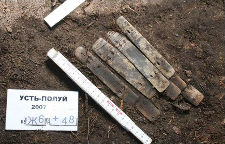
The discovery is the oldest evidence of armour found in the north of western Siberia, and was located at the rich Ust-Polui site, dating to between the 1st century BC and the 1st century AD.
Earlier discoveries at the site indicate a bear cult among these ancient people.
Archeologist Andrey Gusev, from the Scientific Research Centre of the Arctic in Salekhard, said the plates of armour found at the site are all made from reindeer antlers.
'The largest were 23-25 centimetres in length (pictured upper left). Others are 12-14 centimetres in length, thinner and richly ornamented (pictured upper right and bottom).' Pictures: Andrey Gusev
'There are about 30 plates in the collection of Ust-Polui,' he said. 'They differ regarding the degree of preservation, as well as the size, location of mounting holes, and the presence or absence of ornamentation.'
The largest were 23-25 centimetres in length. In ancient times, they would have been fixed to a leather base and offered a reliable means of protection.
Others are 12-14 centimetres in length, thinner and richly ornamented.
'I'm writing still under the impression, as I've just seen these things. This is literally a world scale discovery'. Picture: Bear ring, bronze, finding of 2013, by Andrey Gusev
'The ornamentation on the plates can be individual, that is after the through analysis we could say how many warriors left armour here, judging by the style of decorations.'
Other conical shaped armour is seen as plates on helmets worn by the ancient warriors. 'In the taiga zone of Western Siberia, finds of real iron helmets were extremely rare,' he said. 'But in the middle of the first millennium AD, bronze images appeared of people wearing headdresses clearly resembling helmets.
'A likely explanation may be a long tradition of making antler helmets.'
According to Gusev Yamal armor resembled the design used by Kulai peole. Picture: Alexander Soloviev
Gusev said the armour resembled the warrior picture here, which relates to designs used by the Kualai people, hunters and fishermen native to the taiga.
He believes the armour was deliberately left at Ust-Polui, an ancient sacred place, as a gift or sacrifice to the gods.
As previously revealed by The Siberian Times, a 2,000 year old ring found at the same site is seen as proof of a bear cult among these ancient polar people who left no written records.
Made of high quality bronze, this ancient Arctic jewellery features an image of a bear's head and paws. 'The ring is tiny in diameter so even a young girl, let alone a woman, cannot wear it,' he said. 'We concluded that it was used in a ritual connected with a bear cult and was put on the bear claw.'
A 2,000 year old ring found at the same site is seen as proof of a bear cult among these ancient polar people who left no written records. Pictures: Andrey Gusev
The theory is that the ring was fitted to the claw of a slain bear, an animal worshipped by ancient Khanty tribes as an ancestor and a sacred animal. 'After killing the bear they had a bear festival to honour the animal's memory. The head and front paws a bear was adorned with a handkerchief, rings, and a few days lying in the house.
'This combination of images on the ring and the fact that it was found in the sanctuary of Ust-Polui led us to believe that there was also practiced a bear cult.'
The world’s most famous trade route did not only witness the transfer of silks, spice, and various other commodities, but also humans. Who were the slaves traded along the ancient route? Who were the traders? Where did they come from? Professor Jonathan Skaff from Shippensburg University of Pennsylvania offered answers during a lecture about Silk Road Slave Trade at Turfan during the Tang Dynasty on October 17th. The event was sponsored by NYU Shanghai’s Center for Global Asia.
As he led his NYU Shanghai audience to rediscover the Silk Road from a new angle, Prof. Skaff digged through the history of the Eurasian slave trade between West and East Asia during the 7th and 9th centuries CE. He focused his analysis on the Turfan oasis in the Central Asian Turfan Basin and argued that its arid climate and irrigated agriculture contributed to the trade.
“Central Asian merchants and the elite class in Tang Dynasty were found buying, selling and traveling with human chattels,” asserted Prof. Skaff.
Purchase contracts of slaves written on paper have come to light in several tombs in the Turfan region. Recycled as hats and shoes, the documents were buried along with the corpses and other grave goods. The standard information recorded in such contracts comprised the gender and places of origins of the slaves as well as the names of their sellers and buyers.
In his talk, Prof. Skaff introduced the results of his analysis of the contracts. One of his conclusions was, for example, that Sogdians were most active in the slave trade. He also showed that 80 percent of the caravans dealt with slaves, who accounted for up to 38.5 percent of all travellers.
“The Tang Empire exerted enormous influence on the economics of slave trade. The legal, military, administrative and transportation systems of the Tang Empire facilitated human trafficking by guaranteeing road transportation and enforcing the contracts,” Skaff said, adding that there was no age limit for slaves and most of them were kids from poor families.
The talk was hosted by Interim Director for the Center for Global Asia, Assistant Professor Armin Selbitschka. It was the latest installment in a regular lecture series that is sponsored by the Center of Global Asia and has featured a number of distinguished scholars including Wang Gungwu, Amitav Ghosh, and Prasenjit Duara in the past.
The tomb's entranceway is located on the south wall of the tomb. It was blocked off with bricks 1,000 years ago. Images of two servants can be seen flanking the entrance.
A 1,000-year-old circular tomb, whose walls are decorated with colorful murals, has been discovered in Datong City, in northern China.
Because the tomb's entranceway is sealed off with bricks, archaeologists had to enter through a hole in the deteriorating arch-shaped roof.
The team, from the Datong Municipal Institute of Archaeology, found cremated human remains in an urn in the middle of the tomb. No texts were found in the tomb, but the archaeologists believe that the tomb likely belonged to a husband and wife. [See Photos of the Circular Tomb and Colorful Murals]
Themurals on the wallsshow servants, cranes and numerous articles of clothing that hang on several stands, their colors still vibrant despite the passage of a millennia.
Colorful clothing
Colorful clothing abounds on the tomb's murals. One clothes stand, painted on a mural on the west wall, has "sky blue, beige, bluish-gray, yellowish-brown and pink clothes," wrote the archaeological team in a paper published recently in the journal Chinese Cultural Relics. "The garment to the far right has a green-diamond grid pattern, each diamond of which has a small red decorative flower in it," wrote the archaeologists, noting that another article of clothing has what appears to be a jade ring that "hangs at the waist."
The murals on the west wall of the 1,000-year-old tomb depict articles of clothing as well as two servants.
Credit: Courtesy of Chinese Cultural Relics
Additionally, the mural shows that "in front of the clothes stand there is a long rectangular table, on which are placed four round plates, black on the outside and red inside, holding, respectively, a headdress, bracelets, hairpins and combs," the archaeologists wrote.
On the east wall of the tomb the mural shows another clothes stand. "On the stand hang beige, light green, bluish-gray, pink and brown clothes," the archaeologists wrote. "On one of the garments hangs a ring-shaped pei pendant accompanied by a string of black beads." Pei is a word that can mean "matching" or "accompanying" in English.
Liao Dynasty
The team believes that the tomb likely dates to the Liao Dynasty (A.D. 907–1125). Historical records indicate that this dynasty, controlled by the Khitan, flourished in northern China, Mongolia and parts of Russia.
At that time, people in northern China were sometimes buried in tombs decorated with murals. In 2014, Live Science reportedon the discovery of another tomb containing murals, which was found decorated with images of stars as well as numerous animals, including a crane, deer, yellow turtle and even a cat playingwith a silk ball. That tomb was also excavated by a team from the Datong Municipal Institute of Archaeology.
Archaeologists believe that both mural-decorated tombs will help shed light on those who lived during the Liao Dynasty.
The tomb with the murals showing colorful clothing was excavated by the Datong Municipal Institute of Archaeology team in 2007. The team published a report on the tomb in 2015, in Chinese, in the journal Wenwu. That report was translated into English for publication in Chinese Cultural Relics.
The Pamiri people of Afghanistan and Tajikistan are among the most isolated communities in the world. They live according to centuries-old traditions. Slowly but surely Western influences enter this remote mountain region. In this documentary film we travel through the Pamir Mountains with Frederik van Oudenhoven. He is the author of ‘With our own hands’, a book about the traditional dishes and the food and farming culture of the Pamiri people. It is the first written source about their culture that is accessible in their own language. Frederik brings his book back to its source. He speaks with farmers about the struggles they are facing: can the Pamiri people stay true to their old traditions while adapting to a new world?
11 April 2017: Frederik van Oudenhoven presents the documentary film Wisdom of the Mountains in Leiden University
The Pamir people in Tajikistan and Afghanistan are among the most isolated communities in the world. They live according to century old traditions. Yet slowly but surely the Western world enters this remote mountain area. In the documentary film Wisdom of the Mountains the crew travels through the Pamir Mountains together with Frederik van Oudenhoven. He is the author of ‘With our own hands’, a book about traditional dishes and the food and farming culture of the Pamiri people. He brings his book back to its source. Frederik speaks with farmers about the changes they are facing: Are they staying true to their old traditions or will they – slowly but surely – adopt the Western influences.
About the book In the autumn of 2009, a grandmother in the village of Mun, in the Ghund valley of the Tajik Pamir Mountains, approached two young researchers and asked them to write down her old recipes. “I want to share them with my children and grandchildren while I still remember what I know,” she said.
Surrounded by her family and neighbours, the conversations about the recipes became a passage into the timeworn traditions of the Pamir Mountains and the rapid changes they now face. Over the following years, her voice was joined by those of many other grandmothers and grandfathers, children, teachers and farmers. Together they are this book: a unique and intimate portrait of the Pamir Mountains of Afghanistan and Tajikistan.
"This...may be one of the most beautiful books I have ever read..!" Frénk van der Linden. Listen to the interview with Frederik van Oudenhoven (in Dutch) on Radio 1 from 19 August 2015.
About the authors Frederik and Jamila first met over a bowl of apricot soup in the village of Darmorakht in the Tajik Pamirs. Frederik was introduced to the Pamirs through his research on agricultural biodiversity conservation at Bioversity International in Rome. Jamila was working with the Aga Khan Foundation’s rural development programme.
Frederik is an ethnobiologist who works with smallholder farmers and indigenous communities around the defence of traditional food and agricultural practices. Jamila studies the relationship between poverty and agricultural biodiversity as a PhD candidate at the Stockholm Resilience Centre.
The photographs in this book were taken by three award-winning photographers: Judith Quax, Theodore Kaye and Matthieu Paley. René Put was the graphic designer.
One book, three languages Besides English, the languages in this book are Dari and Tajik. They are the forms of Persian spoken in Afghanistan and Tajikistan respectively. The languages are not as different as their distinctive scripts suggest: Dari and Tajik speakers can understand each other well, yet their different histories have meant that the former is written in the Arabic script, while the latter is in a slightly modified version of Cyrillic.
Most people in the Pamirs speak Dari or Tajik only as their second (or third) language, their mother tongue being one of a number of unwritten Pamiri languages, unrelated to Persian. Partly as a result of these influences, Dari and Tajik are spoken very differently in the countryside of the Pamirs from how they are spoken in the capitals of the two countries, Kabul and Dushanbe. In the translations, we have sought to find a balance between these different ways of speaking the languages which, while comprehensible to all, does not oversimplify the language or take away from its beauty.
The choice to make a book in which the three languages are combined was inspired by the authors' wish to return a copy to each community, school and library in the Pamirs. It is also intended to give expression to the close historical ties between the people on either side of the Afghan–Tajik border, and between them and the people from around the world who will read this book in English.